Research Motivations
Over half of the world's population lives within 25 kilometres of the sea, but for many of them, that zone is rapidly dwindling. Global warming has caused sea levels to rise, accelerating the rate at which coastlines are being eroded - a significant factor in coastal flooding and the cause of hugely expensive damage. Coastal erosion is becoming a more common and destructive process and can have significant and costly effects on human populations. With 50-70% of the global human population living in coastal zones and rising sea levels caused by global warming speeding up beach erosion, researchers need a way to monitor what is happening beneath the surface of the sea.
Data to attempt to understand this phenomenon has largely been obtained by observations and measurements of exposed coastal areas such as beaches to quantify the effects of coastal erosion. While these studies have revealed lots of important information (for example, by determining an empirical formula for estimating the depth of closure) the details of what was happening below the seas surface have not been measurable. This means that we have only a partial picture of coastal erosion because of the absence of this important data.
Attempts to understand coastal erosion processes have until now been largely limited to periodic surveys, often from the air, which have provided little more than an historical record of erosion. But the ASTEC project will go beneath the sea to harvest information key to understanding and predicting erosion patterns.
Engineers have classically modelled the submerged beach profile by describing two different zones nearshore and offshore. The nearshore zone is active while the offshore zone is inactive with respect to the movement of sediment, silt, sand and the like. The dividing contour between these zones is known as the depth of closure. This contour and its movement is important to measure since it gives very useful data regarding the dynamics of sedimentary movement on the seabed and enables more accurate measurements of coastal erosion.
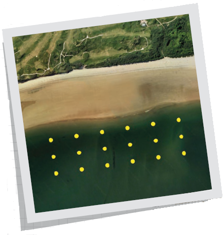
The fundamental purpose of the sensor network is to find the depth of closure and the movement of seabed sediment around this contour. It will only be necessary to monitor seabed movement below the low tide line and the sensors would need to be positioned either side of the closure contour so that a temporal picture of sedimentary movement around this contour could be constructed.
The applications of ASTEC are global as a fifth of the EU coastline is already severely affected; in the UK 140bn of homes and businesses are estimated to be at risk from coastal flooding and erosion; and in the US, where areas of New England and the tourist beaches of California and Florida are under threat, billions of dollars have been spent on coastal defences and rebuilding infrastructure. ASTEC will be an important weapon in the armoury of those fighting the sea costly encroachment.
Research Objectives
A series of sensors on the sea bed will monitor and measure the movement of sediment around the coasts every 15 minutes, effectively measuring the movement of the beach; this data will be transmitted by radio to a collection buoy, which will use the mobile phone system (GSM) to transfer the information to shore. Accurate and detailed information will be gathered in real time, which will lead to more effective sea defences in the past, paucity of information has meant that some protective measures have simply moved the problem along the coast, or even exacerbated it.
The primary purpose of the ASTEC project is to find a technique for measuring the effects of coastal erosion under the sea surface and to consequently evaluate whether remedial action is possible or desirable. The project team are currently developing a flexible and reconfigurable sensor network system that will be placed on the seabed in a specific pattern.
New protocols are being developed to create a mesh network from the deployment of multiple sensors with underwater radio links. Each of the nodes are either sensor nodes, relay nodes or a main data collection and transmission node. The sensor nodes will be fixed and are capable of determining the amount of sediment that is settling on top of them (future systems will also incorporate other measurements such as flow and turbidity). The system can be deployed for many months and so can build up a detailed profile of the movement of sediment at many positions on the seabed. The relay nodes simply relay data sent to them and have no sensing capabilities themselves. Sensor data is gathered at 15-minute intervals and is stored locally over a period of one day. Once per day all the nodes will transfer their day’s data across the sensor network where it will be collected by the sink node. The sink node that will be positioned on a buoy will then transfer this data using the mobile phone (GSM) system. This enables the remote collection and processing of the data.
The system will also gather data regarding the health of the sensor nodes which will also be accessible by the user and enable any failed nodes to be replaced. Until this happens any failed nodes can be avoided via the use of network routing algorithms and data retransmission protocols to enable any data lost in transit to be retransmitted and therefore recovered.
This system is novel because it uses electromagnetic communications to transmit its data. The propagation speed of radio signals in water is significantly slower than that in air and their range is far less due to the conductivity of the water. This effect is even more pronounced in saltwater presenting a host of technical difficulties. Nevertheless, this form of communication has several
significant advantages which make it ideal for this type of application:
-- Radio signalling is unaffected by turbulent aerated water
-- Radio signalling operates well in shallow water
-- Radio signalling is unaffected by dirty water or water with suspended sediment
-- Radio signalling is capable of travelling through the air water interface providing an alternative signal path
-- Radio signalling technology is immune to marine fouling
These features cannot be provided by acoustic or optical technology and significant data errors would occur with these technologies in this turbulent underwater environment. Radio frequency has the added advantage that signals can propagate through the seabed, and the ASTEC system will use this capability to extend the range of the sensor network.
Provision of seabed instrumentation in the coastal erosion zone has historically proven very challenging. Seabed located sensors can be deployed to gather data autonomously but provide no real-time visibility of measured data and may often be subject to failure or shift of position in this highly dynamic environment. Without real-time reporting there is no visibility of sensor failure or movement until sensor recovery is attempted. This is often at the end of a lengthy time period and can result in the loss of a significant data gathering opportunity. Wired sensor systems have been attempted but the deployment of a buried cable from shallow-water, up the beach represents a considerable investment for each monitoring node and is prone to single point failure.
This project has developed a modular system of monitoring nodes which communicate from their position on the seabed using novel underwater radio technology. A prototype system will be deployed during the winter of 2009/10 in a pocket bay that has been extensively studied using on-beach measurements and trials results will be published next year.
In conclusion, this project aims to use new technological innovations and expertise developed by the partners of the consortium to design an underwater sensor network system that is capable of measuring the effects of coastal erosion. This will enable more accurate decisions to be made regarding intervention levels and the type of intervention when such events occur. This will have significant implications for costal management. The results of this project will therefore be the development of an underwater sensor network that will be able to monitor important environmental changes over time. This system represents a step change in
the accuracy, volume and timeliness of data available to the marine engineer.
With worries over global warming and its consequential expected impacts, this project will provide valuable data to quantify these effects more completely and therefore enable coastal defence organisations to make appropriate responses. Because of the vital information that it would provide, such a system has the potential to save many millions of pounds and to have a positive impact on millions of lives around the world.
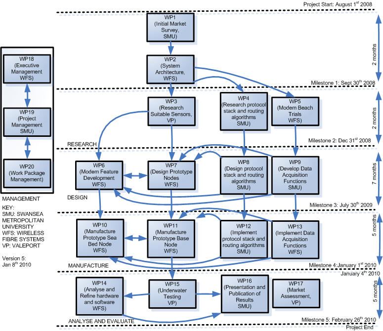
The project plan is shown below:
Technology Strategy Board investment
GBP 435,000
Collaborative research and development projects are one of the tools that the Technology Strategy Board uses to drive innovation in the UK. The Technology Strategy Board is a business-led executive non-departmental public body, established by the Government. Its role is to promote and support research into, and development and exploitation of, technology and
innovation for the benefi t of UK business, in order to increase economic growth and improve the quality of life. It is sponsored by the Department for Business, Innovation and Skills (BIS).
Tel: 01793 442700 www.innovateuk.org